| Ref |
Subject |
Description |
Size |
Price |
Image |
| MX0496 | Kent | Canterbury, 1822. Engraved by James Bingley and published by Longman & Co. Steel engraving. | h 176mm x w 232mm | £50 |  |
| MX0442 | Kent | Kent Drawn from an Actual Survey and Regulated by Astronomical Observat, by T Kitchin. 1748-1784. Copper engraving. Condition - trimmed to edge of map and several folds. | h 145mm x 217mm | £35 |  |
| MX0433 | Kent | Kent by Francis Grosse, c1790. Copper engraving. Text continues on the reverse. Condition - some off-setting at bottom of image. | h 225mm xx w 147mm | £15 |  |
| MX0431 | Kent | Maidstone: Sandwich, c1835. BY J & C Walker. Steel engraving with original/early hand colouring. | h 237mm x w 164mm | £16 |  |
| MX0430 | Kent | Canterbury, 1806. Drawn by G Cole and engraved by J Roper for "The Beauties of England and Wales" by E W Brayley and J Britton, Published by Vernor, Hood, and Sharpe. A vignette of Canterbury, shows the Cathedral and St. Augustine's Gate. Copper engraving. | h 180mm x w 235mm | £100 |  |
| 20 | Kent | John Speed, c1614, uncoloured map, with inset plans of Canterbury and Rochester, English text on verso, hinged on to mount. | | £750 | 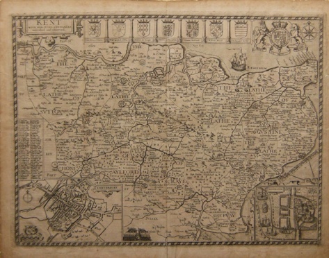 |


