| Ref |
Subject |
Description |
Size |
Price |
Image |
| MX0463 | Britain | Anglia - Inghiterra, 1713. By Lasor a Varea. Text above map and on the reverse. Copper engraving. Condition - horizontal fold above map. | h 105mm x w 143mm | £45 |  |
| MX0462 | Britain | Britannia - Frontispiece c1610. The map of Britain is surrounded by figures and other scenes. Copper engraving. | h 265mm x w 167mm | £250 |  |
| M0385 | Britain | William Stukeley, 1723. In gratiam Itinerantium Curiosorum Antonini Aug. Itinerarium per Britanniam, tentavit (Roads of Roman Britain. | h 275mm x w 245mm | £70 | 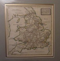 |
| M0327 | Britain | Hondius, c1631 Magnae Britanniae et Hiberniae Tabulae. An attractive and elegantly decorated map of the British Isles. This map was based on an earlier plate engraved by Hondius in 1617. The borders have been removed and the date 1631 added to Hondius' imprint in the lower right-hand corner. The Latin text on the back of the map gives a description of the country. Copper engraving with good margins. | h 380mm x w 510mm | £860 | 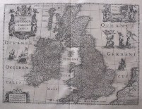 |
| M0233 | Britain | Le D'Auphin, Les Isles Britaniques ou sont les Royaumes D'Angleterre, D'Escosse et d'Irlande | h 317mm x w 222mm | £140 | 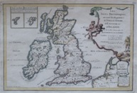 |
| 21 | Britain | Abraham ORTELIUS; Angliae, Scotiae, et Hiberniae, sive Britannicar insularum descriptio, double-page engraved map, decorated with ships, Royal coat-of-arms, and a compass and scale, French and Dutch text on verso in manuscript, ., [Amsterdam, 1570, or later] | 344mm x 500mm | £550 |  |


